Property Details
Penicuik EH26 8PT
Description
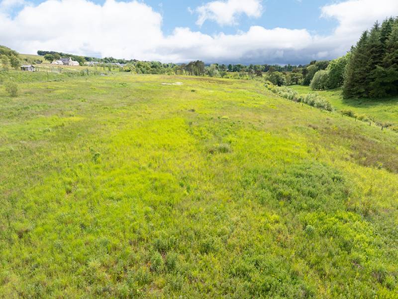
A well situated and fully fenced grazing paddock, suitable for equestrian uses, with additional surrounding trees and amenity land.
Commercial Sold - Penicuik
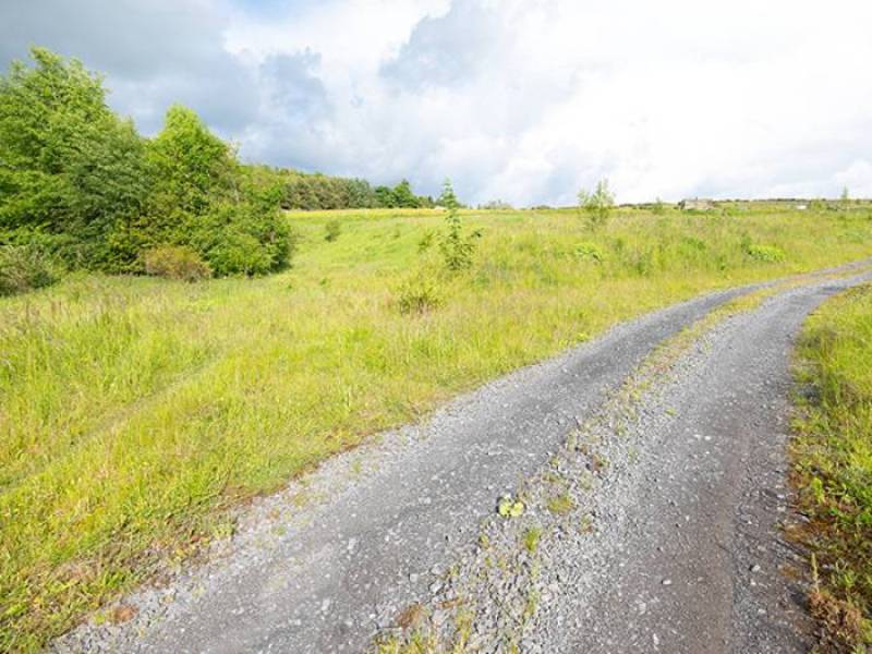
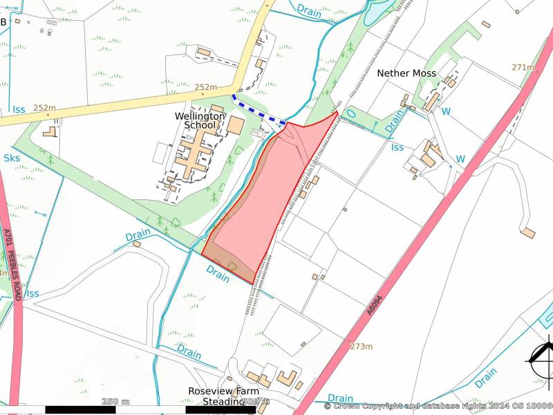
The land comprises a fully fenced single field with a small woodland area at the southern end and areas of amenity land, accessed by a shared hardcore access track. The majority of the land has been relandscaped and altered as part of a previous inert material landfill site. There are no buildings with this land.
The field is currently not occupied or grazed.
There is a small area of woodland at the southern end, comprising mixed mature trees including Scots Pine, beech and other broadleaves, with a smaller area of naturally regenerating broadleaves, including willow and birch, within the south-west corner of the field and adjoining embankment areas.
The land lies at a height of between 240 and 260m above sea level, with a general north-west aspect. The field retains a gentle slope with contours above the natural topography, associated with the landfill area. The landfill edges on the south and west retain steeper sloping embankments, comprising mixed moderate and steep slopes. The land drops down to the west and forms the eastern side of the Lead Burn valley with the Lead Burn itself lying close to the western boundary of the land (but not included with the land being sold).
LOCATION
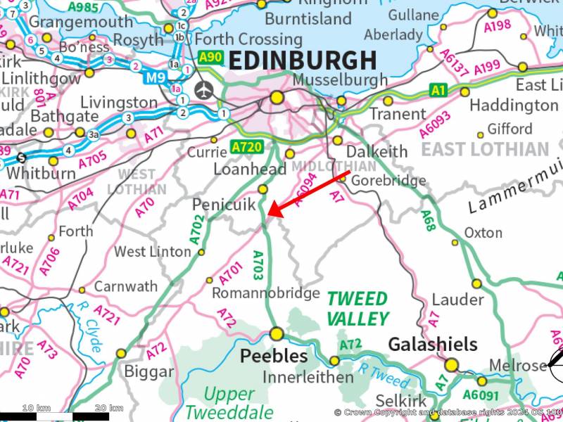
The land lies approximately 3 miles south of Penicuik, with Edinburgh City Centre lying approximately 14 miles to the north. It sits within a rural area with open grassland to the north, south and east, utilised for mixed agricultural/equestrian grazings and dog excercise, along with small tree plantations. The eastern boundary of the land is formed along an old railway track, once forming part of the Peebles to Eskbank railway line. The former Wellington School site lies to the west.
Post Code: EH26 8PT. It is strongly recommended that you do not rely on a Satnav in this rural location and check on a route map prior to any scheduled viewing.
What3Words: ///package.fiery.region
DIRECTIONS
Travelling from the north (Edinburgh), head south on the A701 to Penicuik. Continue on the A701 and carry on through the town. Approximately 1 ½ miles from the edge of the town, turn left onto a “C” classified side road (sign posted – “Leading to Milkhall Cottages”) and continue for a further 200m until the road takes a turn to the left. The shared gate access to the land is on the right hand side, on the outside of the corner. There is space for cars to park off the public road at this point, but please avoid blocking the gate.
From the south, travel north on the A703 to the Leadburn junction and continue onto the A701 heading to Penicuik. Approximately one mile north of Leadburn, turn right onto the “C” classified side road (sign posted – “Leading to Milkhall Cottages”) and continue, as described above.
LAND USE CLASSIFICATION
The surrounding land is identified by the James Hutton Institute for agricultural use as Grade 3:1 and for forestry use as F5. The land for sale is restored land and as such may not match the surrounding land grades.
INTEGRATED ADMINISTRATION AND CONTROL SYSTEM (IACS) & BASIC PAYMENT SCHEME (BPS) ENTITLEMENTS
The land is not registered for IACS (Integrated Administration and Control System) purposes and no Basic Payment Scheme (BPS) entitlements are available.
AREAS
The areas summary of the land is as follows:
Grazing Field 1.67 Ha 4.13 acres
Open mixed trees 0.276 Ha 0.68 acres
Amenity Land 0.641 Ha 1.58 acres
TOTAL 2.587 Ha 6.39 acres
TENURE
The land is offered on a Heritable title basis, with vacant possession.
ACCESS
Access to the land from the “C” classified public road is via a right of way over a private access track, which is owned by a third-party. Full access rights are understood to be retained in favour of the land, however, potential purchasers must satisfy themselves on this matter.
PLANNING HISTORY
The land is subject to a number of planning applications and permissions, as follows:
- Erection of dwellinghouse (ref 05/00182/OUT). Refused.
- Change of use of agricultural land to equestrian centre. Land fill of part of site and erection of stables, barn, outdoor arena and siting of residential caravan and culverting of burn (Ref 06/00681/FUL). Refused.
- Change of use of agricultural land to equestrian centre, land fill of part of site and erection of stables, barn, outdoor arena and formation of bridge (Ref 07/00678/FUL ). Consent with conditions.
- Amendment to Condition 1 of planning permission 07/00678/FUL (change of use of agricultural land to equestrian centre, land fill of part of site and erection of stables, barn, outdoor arena and formation of bridge) to extend timeframe of land filling operation (Ref 10/00203/DPP). Consent with conditions.
Any future development on the land would require a new planning application, which would be determined under current local development plan planning policies.
The former Wellington School site, which lies close by to the west, is outlined for redevelopment within the Local Development Plan (Site AHs5).
Potential purchasers must satisfy themselves on these matters.
RE-INSTATED LANDFILL
The land has been utilised as an inert material landfill site which has been re-instated. Potential purchasers must satisfy themselves on this matter.
THIRD PARTY RIGHTS AND SERVITUDES
The shared access track crosses the subject land at its northern end and is utilised by the adjoining stables and dog exercise areas in addition to an access gate at the north-east corner of the land, providing access to an adjoining grazing field. There are therefore a number of third-party access users to these tracks who retain rights of access over the subject land.
A “Core Path” runs along the adjoining old railway line and crosses the land at its northern end, along with a “Core Path” designation along the shared access track from the public road.
ENVIRONMENTAL MATTERS
There are no Environmental Designations or Scheduled Ancient Monuments.
MINERAL RIGHTS AND SPORTING RIGHTS
Insofar as these rights form part of the seller’s title, they are included within the sale.
VIEWINGS AND FURTHER INFORMATION
For further information or to arrange an appointment to view please contact Walker Scott Ireland Ltd. Viewing is strictly by appointment. Please note that the land may be grazed by stock at the time of viewing and viewers must take all steps not to unduly disturb stock or put themselves in danger by approaching stock in a manner that might cause them disturbance.
Interested parties are advised to note interest with Walker Scott Ireland Ltd in order to be kept informed of any closing date that is set. Please note, our client need not accept the highest offer, nor indeed any offer.
ANTI-MONEY LAUNDERING REGULATIONS
To comply with current Anti-Money Laundering Regulations, any offer presented must be accompanied with Notarised/certified photographic evidence of the purchaser’s identity and separate evidence of the purchaser’s residential address, or the offering parties must attend our offices with the original documents, before any acceptance of the offer can be confirmed and the property put “Under Offer”.
Property Features
- Land is 6.39 acres


